


توضیحات Volcanoes & Earthquakes
Volcanoes & Earthquakes shows the latest world-wide earthquakes (or only quakes near you), as well as earthquake "I-felt-it" reports, in near real-time and active volcanoes on a map and as list, as well as volcano news from all the world.
You can filter the data shown in various ways, e.g. by magnitude or age of earthquakes, the distance from your location, the status of volcanoes and so on.
!*****! Write a nice 5-star review to keep the developer motivated to continue working on this app;-)
Features:
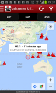
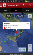
- See currently erupting volcanoes on a map (more than 1600 active and dormant volcanoes)
- Get most recent volcano news, including volcanic ash advisories (since v.1.4)
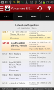
- See the most recent earthquakes around the world - based on one of the most complete and accurate earthquake data sets on the net; earthquakes worldwide up to 7 days old
- Notifications: near-real time earthquake & volcano alerts
- Custom alerts for user-set locations / areas
- Optional background update at custom interval
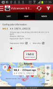
- Alert if earthquakes might have been felt at your location
- Larger earthquakes (above magnitude 6) available for up to 1 year
- Listing of earthquakes near active volcanoes (could be indications of volcanic unrest)
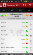
- Complete volcano listing worldwide A-Z / by country / by activity level (since v. 1.4.)
- Multiple data sources (more than 40 international and national data sources)
- Filter earthquakes according to magnitude, age and distance
- Filter quakes by continent, country or state (since 2.3.0)
- Sort quakes by time (latest) or size (magnitude)
- Earthquake catalogue (archive) since 2012 - probably the most complete available on the web (since 2.3.0)
- Earthquake stats (magnitude / energy / depth vs time or magnitude) (since 2.4.0)
- Submit / read / view (on map) experience reports ("I-felt-an-earthquake")
- Detail information about each earthquake
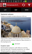
- Detail information about each volcano (incl. eruption list, eruption style)
- "I-felt-an-earthquake" reports shown on map
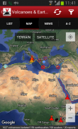
- Tectonic plate boundaries
- Highly compressed data format to save bandwidth
- Optional automatic background loading of data
- You can submit us a feature request through comments!
Planned features:
- Automatic custom alerts
- Add more data sources
- Earthquake news
Earthquake data sources (often updated) currently in use:
- BGS: British Geological Survey
- CEIC: China Earthquake Information Centre
- EMSD: Камчатский филиал Геофизической службы (Russian Academy of Science)
- EMSC: European-Mediterranean Seismological Centre
- IGEPN: Instituto Geofísico - EPN
- IGN: Instituto Geográfico Nacional
- IMO: Icelandic Met Office
- IGP: Instituto Geofísico del Perú
- INGEOMINAS: Red Sismológica Nacional de Colombia
- INGV: Istituto Nazionale di Geofisica e Vulcanologia
- IRSC: Iranian Seismological Center
- LGRB: Landesamt für Geologie, Rohstoffe und Bergbau
- GeoAu: Geoscience Australia
- GEONET (NZ): New Zealand Earthquake Commission and GNS Science
- GFZ: Deutsches GeoForschungsZentrum Potzdam
- GUG (U. Chile): Centro Sismológico Nacional, Universidad de Chile
- KOERI-RETMC: BOUN KOERI Regional Earthquake-Tsunami Monitoring Center
- NOA_HL: Institute of Geodynamics - National Observatory of Athens
- NRCAN: Earthquakes Canada
- PHILVOLCS: Philippine Institute of Volcanology and Seismology
- SED: Schweizerischer Erdbebendienst
- SSN: Servicio Sismológico Nacional
- Univ. Helsinki: University of Helsinki - Institute of Seismology
- USGS: Earthquake Hazards Program / USGS
Disclaimer:
Although we collect data carefully and maintain the application as well as possible, there is no warranty for correctness or completeness of the information and the functionality of the app.
The app has no governmental affiliation and should not be used for disaster prevention, planning and other serious businesses.
آتشفشان ها و زمین لرزه ها آخرین زمین لرزه های جهان را نشان می دهد (و یا تنها در نزدیکی شما زمین می کشد) و همچنین زمین لرزه گزارش می کند که "I-felt-it" در آتشفشان های نزدیک به زمان واقعی و فعال بر روی نقشه و لیست و همچنین آتشفشان اخبار از سراسر جهان
شما می توانید داده های نشان داده شده در روش های مختلف را فیلتر کنید، برای مثال توسط بزرگ یا سابقه زلزله، فاصله از محل خود، وضعیت آتشفشان ها و غیره.
*****! نقد و بررسی 5 ستاره خوب را برای حفظ انگیزه توسعهدهنده برای ادامه کار در این برنامه بنویسید ؛-)
امکانات:
- مشاهده آتشفشان ها در حال حاضر بر روی یک نقشه (بیش از 1600 آتشفشان فعال و خاموش)
- دریافت آخرین اخبار آتشفشان، از جمله توصیه های آتشفشانی خاکستر (از v.1.4)
- آخرین زلزله های جهان را ببینید - بر اساس یکی از کامل ترین و دقیق ترین داده های زلزله در شبکه؛ زمین لرزه ها در سراسر جهان تا 7 روزگی
- اطلاعیه ها: زلزله نزدیک به زمان واقعی و هشدار آتشفشان
- هشدار سفارشی برای مکان / مناطق کاربر تعیین شده
- به روز رسانی پس زمینه اختیاری در فاصله سفارشی
- هشدار اگر زمین لرزه ممکن است در محل شما احساس شده است
- زلزله بزرگتر (بیش از حد 6) در دسترس است تا 1 سال
- فهرست زمین لرزه ها در نزدیکی آتشفشان های فعال (می تواند نشانه هایی از ناآرامی های آتشفشانی باشد)
- فهرست آتشفشان کامل در سراسر جهان A-Z / بر اساس کشور / توسط سطح فعالیت (از v. 1.4)
- منابع داده های چندگانه (بیش از 40 منبع اطلاعات بین المللی و ملی)
- زلزله های فیلتر بر اساس اندازه، سن و فاصله
- زمین زلزله را از قاره، کشور و یا دولت (از 2.3.0)
- زلزله مرتب کردن بر اساس زمان (آخرین) و یا اندازه (قدر)
- فهرست زلزله (آرشیو) از سال 2012 - احتمالا کامل ترین موجود در وب (از 2.3.0)
- آمار زلزله (قدر / انرژی / عمق در مقابل زمان یا اندازه) (از 2.4.0)
- ثبت گزارش / خواندن / مشاهده (بر روی نقشه) گزارش های تجربه ("I-felt-a-earthquake")
- جزئیات اطلاعات مربوط به هر زلزله
- جزئیات اطلاعات مربوط به هر آتشفشان (شامل لیست فوران، سبک فوران)
- گزارش های "I-felt-a-earthquake" در نقشه نشان داده شده است
- مرزهای زمین شناسی تکتونیکی
- فرمت داده بسیار فشرده برای صرفه جویی در پهنای باند
- اختیاری بارگیری خودکار پس زمینه از داده ها
- شما می توانید یک درخواست ویژگی از طریق نظرات ارسال کنید!
ویژگی های برنامه ریزی شده:
- هشدارهای خودکار سفارشی
- اضافه کردن منابع داده بیشتر
- اخبار زلزله
منابع داده زلزله (اغلب به روز شده) در حال حاضر در حال استفاده هستند:
- BGS: سازمان زمین شناسی بریتانیا
- CEIC: مرکز اطلاعات زلزله چین
- EMSD: Камчатский филиал Геофизической службы (آکادمی علوم روسی)
- EMSC: مرکز زلزله اروپا و مدیترانه
- IGEPN: Instituto Geofísico - EPN
- IGN: Instituto Geográfico Nacional
- IMO: اداره ملاقات ایسلندی
- IGP: Instituto Geofísico del Perú
- INGEOMINAS: Sismológica سرخ ملی از کلمبیا
- INGV: Istituto Nazionale di Geofisica و Vulcanologia
- IRSC: مرکز زلزله شناسي ايران
- LGRB: Landesamt für Geologie، Rohstoffe und Bergbau
- GeoAu: علوم زمین استرالیا
- GEONET (NZ): کمیته زلزله نیوزلند و علوم GNS
- GFZ: Deutsches GeoForschungsZentrum Potzdam
- GUG (U. شیلی): Centro Sismológico Nacional، Universidad de Chile
- KOERI-RETMC: BOUN KOERI مرکز نظارت زلزله-سونامی منطقه ای
- NOA_HL: موسسه ژئودینامیک - رصدخانه ملی آتن
- NRCAN: زلزله کانادا
- PHILVOLCS: موسسه فیلیپین آتش نشانی و زلزله شناسی
- SED: Schweizerischer Erdbebendienst
- SSN: Servicio Sismológico Nacional
- Univ. هلسینکی: دانشگاه هلسینکی - مؤسسه زلزله شناسی
- USGS: برنامه خطرات زلزله / USGS
سلب مسئولیت:
اگر چه ما به دقت جمع آوری داده ها و حفظ نرم افزار و همچنین ممکن است، هیچ گارانتی برای صحت و یا کامل بودن اطلاعات و عملکرد برنامه وجود دارد.
برنامه دارای وابستگی دولتی نیست و نباید برای جلوگیری از حوادث، برنامه ریزی و سایر مشاغل جدی مورد استفاده قرار گیرد.
Volcanoes & Earthquakes - نسخه 2.15.0
(09-10-2023)Volcanoes & Earthquakes - اطلاعات APK
نسخه APK: 2.15.0حزمة: com.volcanodiscovery.volcanodiscoveryاپلیکیشنها در دسته مشابه
شاید دوست داشته باشید...


